Log in
All resources
Create a design
5,876 Free Artworks of Image Map
description de l'universe
alain manesson mallet
maps in the library of congress
the comprehensive history of england (1876)
english-language maps showing history
1870s maps showing history
1685 maps of europe
17th-century maps of italy
zehn karten und ansichten den schlachtfelden des amerikanischen unabhängigkeitskreiges in den staaten pennsylvanien und new york
paintings of battles of the american revolutionary war
asia noviter delineata
1617 drawings
map of the german empire by louis stanislas d'arcy de la rochette
cartouches by louis stanislas d'arcy de la rochette
map of the german empire by louis stanislas d'arcy de la rochette
cartouches by louis stanislas d'arcy de la rochette
the cruise of the marchesa (1889)
1880s maps of the philippines
the cruise of the marchesa (1889)
19th-century maps of borneo
details of images of venice by jacopo de' barbari
jacopo de' barbari
map of paris by braun & hogenberg - derivative files
rue montmartre (paris)
portsmouth earthworks maps
squier and davis images
maps of hrodna by braun & hogenberg
historical images of hrodna
topographia helvetiae, rhaetiae et valesiae (1654) engravings
baroque
ghosts & ghoulish scenes
maps in the stadsarchief amsterdam
hendrik de leth
maps in the library of congress
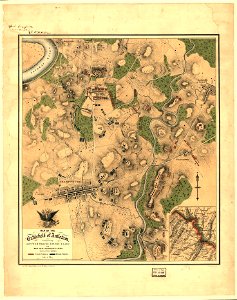
maps of the battle of antietam
maps by jodocus hondius
1590s maps of the world
library of the university of vienna
map of vienna by jacob hoefnagel
celeberrimi fluvii albis nova delineatio by willem janszoon blaeu
old maps of germany from deutsche fotothek
battle of levice
baroque
hortus sanitatis, 1497
hieronymus brunschwig
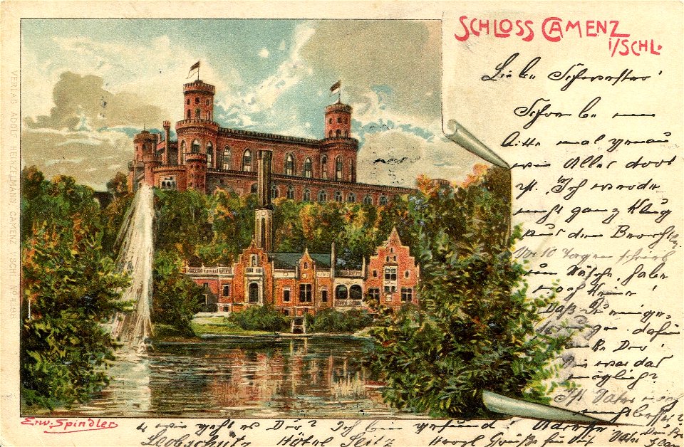
postcards of powiat ząbkowicki
postcards of silesia
historical images of barbakan in kraków
dzieje krakowa (1911)
map of vienna by jacob hoefnagel
stubenbrücke
a treatise on ore deposits (1896)
1890s maps of saxony
french-language maps of south africa
1876 maps of africa
1876 maps of north america
1876 maps of the caribbean
1876 maps of the united states
old maps of new england
nouveau cours d'instruction primaire de géographie (1886)
1886 maps of france
with the armies of the balkans and at gallipoli (1880)
battle of gallipoli
description de l'universe
old maps of greece
map of ghent by jan blaeu
flandria illustrata
maps from encyclopædia britannica
emery walker
1779 maps of new york (state)
old maps of new york (state)
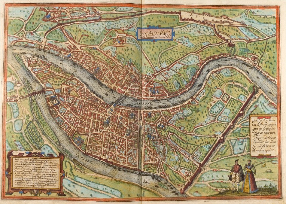
maps of lyon by braun & hogenberg
historical images of lyon
17th-century maps of france
description de l'universe
description de l'universe
old maps of canada
description de l'universe
1685 maps of europe
description de l'universe
1680s maps of portugal
description de l'universe
1685 maps of europe
description de l'universe
old maps of lemnos
description de l'universe
17th-century maps of cuba
description de l'universe
1680s maps of germany
17th-century maps of italy
description de l'universe
description de l'universe
1685 maps of europe
description de l'universe
old maps of scotland
description de l'universe
1680s maps of germany
description de l'universe
1680s maps of brazil
17th-century maps of france
description de l'universe
17th-century maps of italy
description de l'universe
description de l'universe
1685 maps of europe
description de l'universe
old maps of cádiz
description de l'universe
old maps of french guiana
description de l'universe
1685 maps of europe
1685 maps of the caribbean
description de l'universe
description de l'universe
old maps of north america
17th-century maps of bavaria
description de l'universe
17th-century maps of italy
description de l'universe
description de l'universe
1685 maps of europe
old maps of the united states
description de l'universe
17th-century maps of guyana
description de l'universe
description de l'universe
1685 maps of the bahamas
17th-century maps of france
description de l'universe
description de l'universe
1680s maps of cyprus
17th-century maps of italy
description de l'universe
topographia helvetiae, rhaetiae et valesiae (1654) engravings
history of appenzell
maps from the earth and its inhabitants, vol. iv
old maps of the lake district
plan de roussel - derivative files
maps of courbevoie
lumenera skynyx 2-1 images of the moon
piazzi smyth (crater)
maps of hrodna by braun & hogenberg
historical images of hrodna
maps of hrodna by braun & hogenberg
historical images of hrodna
herman diederik joan van schevichaven
revolt of the batavi
herman diederik joan van schevichaven
maps of the history of belgium
maps in the stadsarchief amsterdam
caspar philips
maps in the library of congress
1750s maps of the americas
maps in the library of congress
1708 maps
the dominion of portugal in africa (1889)
maps of cefala by braun & hogenberg
lamont (lunar crater)
arago (lunar crater)
maps in the library of congress
propaganda map
a map of the british empire in america with the french and spanish settlements adjacent thereto
maps in the library of congress
a map of the british empire in america with the french and spanish settlements adjacent thereto
maps in the library of congress
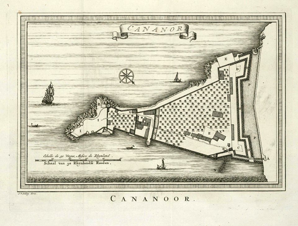
maps of the dutch east india company - india
historical images of st. angelo fort
maps of bergen (norway) by braun & hogenberg
hieronymus scholeus
maps from the earth and its inhabitants, vol. vii
treaty ports
the comprehensive history of england (1876)
english-language maps showing history
the comprehensive history of england (1876)
english-language maps showing history
the comprehensive history of england (1876)
english-language maps showing history
the comprehensive history of england (1876)
english-language maps showing history
the comprehensive history of england (1876)
english-language maps showing history
the comprehensive history of england (1876)
english-language maps showing history
zehn karten und ansichten den schlachtfelden des amerikanischen unabhängigkeitskreiges in den staaten pennsylvanien und new york
maps in the library of congress
zehn karten und ansichten den schlachtfelden des amerikanischen unabhängigkeitskreiges in den staaten pennsylvanien und new york
maps in the library of congress
zehn karten und ansichten den schlachtfelden des amerikanischen unabhängigkeitskreiges in den staaten pennsylvanien und new york
maps in the library of congress
zehn karten und ansichten den schlachtfelden des amerikanischen unabhängigkeitskreiges in den staaten pennsylvanien und new york
maps in the library of congress
new york and brooklyn, with jersey city and hoboken water front
maps in the library of congress
maps in the library of congress
birds-eye view of seattle, 1884
new york and brooklyn, with jersey city and hoboken water front
maps in the library of congress
maps in the library of congress
1771 maps of north america
maps by pieter van der keere
southwark, london
a popular history of the mexican people (1888)
reconstructions of old maps
maps in musée de la compagnie des indes
images requiring restoration
old maps of limburg, netherlands
1884 in limburg (netherlands)
the comprehensive history of england (1876)
english-language maps showing history
701 - 800 of 5,876
Next page
/ 59